Bangladesh Map is the fabulously beautiful map in the universe. Beautiful Bangladesh is a land of beauty and a land of the river. Both portions make it a naturally beautiful country like a heaven on this earth.
Here in this post, I will share with you the encyclopedia of Bangladesh Maps, Bangladesh Division Maps, Bangladesh Districts Maps, Bangladesh Satellite Map, BD Railway Map, BD Road Map, and The capital city Dhaka Map. All the maps highlight with full detail like area, food, beautiful place, history of it, and so more you can’t imagine!
First wanna make a review with a clear idea of Maps Of Bangladesh. So, let’s place your eye on appear part below steps.
Bangladesh, located in South Asia, is a country known for its rich cultural heritage, natural beauty, and vibrant history. The administrative structure of Bangladesh is divided into several layers, the two primary ones being divisions and districts. Understanding this administrative framework is crucial for anyone looking to explore or understand the country’s governance, geography, and demographics. This article provides a comprehensive overview of the divisions and districts of Bangladesh, along with maps for visual understanding.
Table of Contents
Overview of Bangladesh’s Administrative Structure
Bangladesh is administratively divided into 8 divisions and 64 districts. Each division is named after its respective divisional capital and further subdivided into districts, which are locally known as zilas. These districts are further subdivided into sub-districts or upazilas. Understanding the division and district structure helps in understanding how governance, law enforcement, and development initiatives are implemented throughout the country.
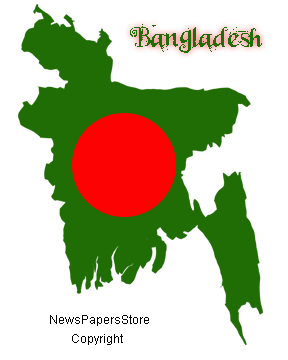
About Bangladesh Map
Bangladesh is a country located in South Asia and bordered by India to the north, east and west, and Myanmar to the southeast. The country has a total area of 147,570 square kilometers (56,977 square miles) and has a population of over 166 million people, making it one of the most densely populated countries in the world.
The country’s geography is characterized by its low-lying river delta, with the Ganges, Brahmaputra, and Meghna rivers flowing through the country before emptying into the Bay of Bengal. The country has a vast network of rivers and waterways, and about one-third of the country is covered in forests.
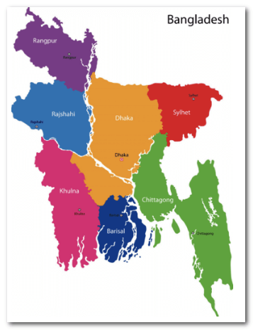
Bangladesh is divided into eight administrative divisions: Barisal, Chittagong, Dhaka, Khulna, Mymensingh, Rajshahi, Rangpur, and Sylhet. These divisions are further divided into 64 districts.
The capital city of Bangladesh is Dhaka, which is also the largest city in the country. Other major cities include Chittagong, Khulna, and Rajshahi. The country is home to many important cultural and historical sites, including the ancient Buddhist ruins in Paharpur, the Sundarbans mangrove forest, and the historic city of Bagerhat.
Bangladesh has a diverse economy that includes agriculture, textile manufacturing, and remittances from overseas workers. The country is also known for its vibrant culture, including music, dance, and cuisine, which reflects its long and rich history.
Overall, Bangladesh is a fascinating country with a unique geography, rich culture, and a rapidly growing economy. Its map reflects the country’s varied landscapes and diverse communities, and highlights the many opportunities for exploration and discovery that it offers.
Concerning To Bangladesh Map
Bangladesh is a country of peace and nature. It’s called the name of Sonar Bangla. It is the country of Asia continent. The southeast part of Bangladesh is the Bay Of Bengal and Myanmar country. The county is surrounded by India on all, outside of a small border. The Country is independent in 1971 in exchange for the blood of martyrs. In the previous time, it was the part of Pakistan and Bangladesh Map was the extra part of Pakistani Map. After 9 month of war, Bangladesh achieved independence and a nice beautiful BD Map(B=Bangla, D=Desh). The map looks like an incredible art of an artist! The Bangladesh Flag is red in green and the map is celestial design.
Cities Of Bangladesh:
Dhaka City(The main city of Bangladesh), Bandarban, Barisal, Rajshahi, Bhola, Bogra, Chittagong, Comilla(Second city of Bangladesh), Cox’s Bazar, Gazipur, Dinajpur, Habiganj, Jamalpur, Jaria, Khulna, Mymensingh, Rangamati, Rangpur, Sylhet, Saidpur, Tangail.
River Of Bangladesh On The Map:
Bay of Bengal(The Ocean Of Bangladesh).
Padma, Meghna, Jamuna, Karnaphuli, Vromopurto(The main five rivers of Bangladesh)
Kaptai Lake(The largest lake in Bangladesh which produce electricity to Bangladesh)
Island Of Bangladesh: Saint Martin Island, Barkal Lake, Kutubdia Island, Sandwip Island, Monpura Island, Sonar Chor, Rupar Chor.
Others Popular River In Bangladesh: Surma River, Tista River, Korotoya River, Madhumati River, Jamuneswari River.
Maps Of Bangladesh Bangladesh Wiki
Full Name Of Bangladesh: The People’s Republic of Bangladesh
Nickname: Bangladesh
Location In Continent: South Asia
Bangladesh Status: Independent Country
The Capital Of Bangladesh: Dhaka
Population Of Bangladesh: 164.7 million (2020)
Principal Religions Of Bangladesh: Islam
Main Languages Of Bangladesh: Bengali
Bangladesh Area: 148,460 km² New
Map of Bangladesh
Bangladesh is a riverine country. In Bangladesh Map, all the districts stand beside a river. There are 8 Division in Bangladesh and 64 districts. The districts are surrounded by the 8 Division. The map of Bangladesh makes them separate from an individual map of them.
Now this time Bangladesh has 8 divisions. Name of them Dhaka Divisio, Barisal Division, Chittagong Division, Khulna Division, Rajshahi Division, Mymenshing Division, Rangpur Division, Sylhet Division.
Bangladesh District Map
Barisal Division’s District:
Barguna District(বরগুনা), Bhola District(ভোলা), Barisal District(বরিশাল), Patuakhali District(পটুয়াখালী), Jhalokati District(ঝালকাঠি), Pirojpur District (পিরোজপুর).
Chittagong Division’s District:
Bandarban District(বান্দরবান), Bandarban District(বান্দরবান), Chandpur District(চাঁদপুর), Chittagong District(চট্টগ্রাম), Comilla District(কুমিল্লা), Cox’s Bazar District(কক্সবাজার), Feni District(ফেনী), Khagrachhari District(খাগড়াছড়ি), Lakshmipur District(লক্ষ্মীপুর), Noakhali District(নোয়াখালী), Rangamati District(রাঙ্গামাটি).
Dhaka Division’s District:
Dhaka District(ঢাকা), Fadidpur District(ফরিদপুর), Gopalganj District(গোপালগঞ্জ), Gazipur District(গাজীপুর), Kishoreganj District(কিশোরগঞ্জ), Madaripur District(মাদারীপুর), Manikganj District(মানিকগঞ্জ), Munshiganj District(মুন্সীগঞ্জ), Narayanganj District(নারায়ণগঞ্জ), Narsingdi District(নরসিংদী), Rajbari District(রাজবাড়ী), Shariatpur District(শরীয়তপুর), Tangail District(টাঙ্গাইল).
Khulna Division’s District:
Bagerhat District(বাগেরহাট), Chuadanga District(চুয়াডাঙ্গা), Jessore District(যশোর), Jhenaidah District(ঝিনাইদহ), Khulna District(খুলনা), Kushtia District(কুষ্টিয়া), Magura District(মাগুরা), Meherpur District(মেহেরপুর), Narail District(নড়াইল), Satkhira District(সাতক্ষিরা).
Mymensingh Division’s District:
Jamalpur District(জামালপুর), Mymensingh District(ময়মনসিংহ), Netrokona District(নেত্রকোনা), Sherpur District(শেরপুর).
Rajshahi Division’s District:
Bogra District(বগুড়া), Joypurhat District(জয়পুরহাট), Naogaon District(নওগাঁ), Natore District(নাটোর), Chapai Nawabganj District(চাঁপাই নবাবগঞ্জ), Pabna District(পাবনা), Rajshahi District(রাজশাহী), Sirajganj District(সিরাজগঞ্জ).
Rangpur Division’s District:
Dinajpur District(দিনাজপুর), Gaibandha District(গাইবান্ধা), Kurigram District(কুড়িগ্রাম), Lalmonirhat District(লালমনিরহাট), Nilphamari District(নীলফামারী), Panchagarh District(পঞ্চগড়), Rangpur District(রংপুর), Thakurgaon District(ঠাকুরগাঁও).
Sylhet Division’s District:
Habiganj District(হবিগঞ্জ), Moulvibazar District(মৌলভীবাজার), Sunamganj District(সুনামগঞ্জ), Sylhet District(সিলেট).
All the districts and divisions are well placed on BD Map. From them, Dhaka Map is more popular in BD Map as well as google search.
Why Dhaka City Map Is Popular In BD Map Area?
The cause of Dhaka is the main town of Bangladesh and Maximum People search in Google as the keyword is Dhaka Map from Finding The Location for financial or business purpose.
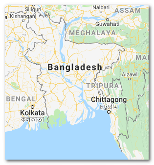
Google Map Bangladesh
You can find this map on Google. Google Search highlighted this image on the google search bar. If you search the keyword on google is Google Map Bangladesh.
Bangladesh Satellite Map
Divisional Area In Bangladesh
Here in this map highlighted all the divisions of Bangladesh separately. Now I want to share the detail of every single division of Bangladesh with all of you. So, let’s see.
Bangladesh Map 64 Districts
Dhaka Division Area Circumstantial:
City: Dhaka
District: 13
Upazila: 123
Union Council: 1248
Area: 20,593.74 km
Barishal Division Area Circumstantial:
City: Barishal
District: 6
Upazila: 39
Union Council: 333
Area: 13,225.20 km
Chittagong Division Area Circumstantial:
City: Chittagong
District: 11
Upazila: 101
Union Council: 949
Area: 33,908.55 km
Khulna Division Area Circumstantial:
City: Khulna
District: 10
Upazila: 59
Union Council: 270
Area: 22,284.22 km
Mymensingh Division Area Circumstantial:
City: Mymensingh
District: 4
Upazila: 34
Union Council: 350
Area: 10,584.06 km
Rajshahi Division Area Circumstantial:
City: Rajshahi
District: 8
Upazila: 70
Union Council: 558
Area: 18,153.08 km
Rangpur Division Area Circumstantial:
City: Rangpur
District: 8
Upazila: 58
Union Council: 536
Area: 16,184.99 km
Sylhet Division Area Circumstantial:
City: Sylhet
District: 4
Upazila: 38
Union Council: 5334
Area: 12,635.22 km
Total District 64, Total Upazila 522, Total Union Council 4,576, Total Area Of Bangladesh is 147,571.00 km.
Done! You can learn here all the local areas and Geographical locations with Bangladesh Map and It’s A-Z Detail. This post writing based on pure information and guidance. Don’t be embarrassed to learn here Like Bangla ePaper, Bangla TV Channel, Bangla Magazine, Bangla FM Radio, Prothom Alo NewsSite, eProthomAlo, Bangladesh Banks.
Importance of Bangladesh’s Administrative Divisions
Each division and its respective districts play a significant role in governance, economic planning, and social development. The administrative division helps in decentralizing power and distributing resources to even the most remote regions of the country. Each division’s distinct geographical, cultural, and economic features offer unique opportunities and challenges for development.
Conclusion
Bangladesh’s administrative divisions and districts provide a comprehensive structure that helps in the country’s overall governance and development. By understanding the divisions and their respective districts, you can gain insights into the country’s geography, culture, and economic activities. Whether you are a traveler, researcher, or policy-maker, having a clear understanding of Bangladesh’s map with its divisions and districts can significantly enhance your knowledge and experience.
FAQs
Q: What is Bangladesh?
A: Bangladesh is a country located in South Asia, bordered by India to the north, east, and west, Myanmar to the southeast, and the Bay of Bengal to the south.
Q: What is a Bangladesh map?
A: A Bangladesh map is a graphical representation of the country’s physical and political features, such as its borders, cities, rivers, highways, and landmarks.
Q: Where can I find a bd map?
A: You can find a Bangladesh map online through various sources such as Google Maps, MapQuest, and the website of the Bangladesh government. You can also purchase physical copies of the map from bookstores or online retailers.
Q: What are the different types of Bangladesh map 64 districts?
A: There are different types of Bangladesh maps such as physical maps, political maps, topographic maps, road maps, and tourist maps. Physical maps show the physical features of the country, while political maps show the administrative boundaries and cities. Topographic maps show the relief of the land, while road maps show highways and road networks. Tourist maps highlight popular destinations and attractions.
Q: What are the main features of google Maps Bangladesh?
A: The main features of a Bangladesh map include its borders, cities, rivers, highways, landmarks, and administrative boundaries. The map may also show important geographic features such as mountains, valleys, and coastlines.
Q: How accurate are Dhaka Bangladesh map?
A: The accuracy of Bangladesh maps can vary depending on the source and the purpose of the map. Generally, maps created by reputable sources such as government agencies or professional cartographers tend to be more accurate. However, it’s always a good idea to cross-reference the information with other sources to ensure accuracy.
Q: Can I use a Bangladesh district map for navigation?
A: Yes, you can use a Bangladesh map for navigation. However, it’s important to ensure that the map you are using is up-to-date and accurate. It’s also recommended to use GPS technology and other navigational aids to supplement the map.
Q: What is the best way to read a map of Bangladesh?
A: The best way to read a Bangladesh map is to start by identifying the key features such as the borders, cities, rivers, and highways. You can then use the scale to determine distances between different locations and the legend to understand any symbols or colors used on the map. It’s also helpful to refer to other sources of information to supplement the map.
Q: Can I download a digital Bangladesh map for offline use?
A: Yes, you can download a Bangladesh map for offline use using various map applications or websites. This is particularly useful if you are traveling to areas with limited internet access or if you prefer not to rely on online maps.